Bureau of Meteorology Rain Radar
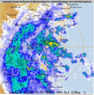
The weather radar network of the BOM can show you precipitation rates and cloud buildups pretty much anywhere on the Australian coast. For trip planning, the real time radar readout shows where the rain is, where it's going, and with a little interpretation and the right atmospherics, can help you pick the location of the East Australian Current as described in one of the articles on this website. By clicking on the radar picture on the left (taken during the most recent of the North coast's "100-year storms"), you'll be looking at the cloud cover and precipitation conditions on the coast as seen by the Grafton weather radar station.
With most smartphones, you can connect to the radar system in real time to see if the storm on the horizon is building, and if it's headed your way. You can then make an informed decision based on the intensity of the rain (and associated destructive microbursts from large cells) and determine if a strategic retreat to the harbour is warranted, or if it might be OK to stay out fishing in the sunshine while the storm blows through and beats up the coast well away from your location.
With most smartphones, you can connect to the radar system in real time to see if the storm on the horizon is building, and if it's headed your way. You can then make an informed decision based on the intensity of the rain (and associated destructive microbursts from large cells) and determine if a strategic retreat to the harbour is warranted, or if it might be OK to stay out fishing in the sunshine while the storm blows through and beats up the coast well away from your location.
